
NGIS revolutionise agriculture with precise tool
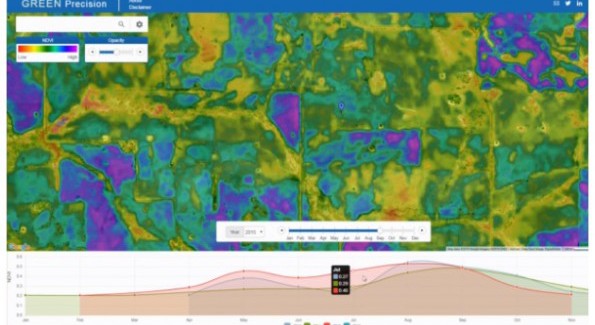
Nathan Eaton, Principal Consultant of NGIS says that this scale of information has never been readily accessible before: “…certainly not in a way where users can graph vegetation statistics for any location across multiple years, and certainly not in a free and easy to use website like we have done with Green Precision.”
“When the user clicks on a location we are processing worldwide Landsat mosaics and pulling data from petabytes of imagery to graph the specific NDVI values for a specific location over the last 4 years.”
“The actual computation required is enormous… This job would not have been done without cloud computing.”
NGIS used Google Earth Engine to provide access and analysis to huge catalogues of satellite imagery.
Asked if NGIS will be including predictive analysis, Eaton’s answer implies there is no limit for NGIS: “Predictive analysis is something we are looking at for other applications along with a range of other features that provide answers and insights.”
“Green Precision is an easy to use, freely available entry level application and we are really interested to see how much value users get from the site.”
(Source – http://www.spatialsource.com.au/2016/04/19/ngis-revolutionise-agriculture-with-smart-planning-tool/)


Submit a Comment