
AutoCopter allows variable-rate Rx in the field
Growers and crop consultants can make decisions in the field using real-time information from the AutoCopter G15 Ag Solution. The unmanned helicopter now provides the ability to collect multi-spectral data using patent-pending software and creates variable rate prescriptions within minutes from landing in the field.
Earlier AutoCopter Corporation released the unmanned aerial vehicle (UAV) precision agriculture solution to collect multi-spectral data and convert it to GeoTiff images. In addition to these features was the ability to see the field live with video streamed to the ground control station, creating geo-referenced DLSR images and HD video at the same time.
“The amount of data is growing, but the amount to real-time data for decision making is often delayed. AutoCopter focused on collecting data and then providing it in the field—where our decisions are made and executed,” reported a Curtis, Neb., crop consultant.
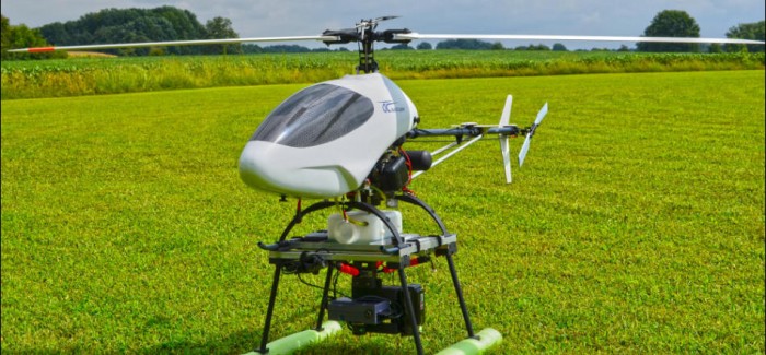
“The AutoCopter has a precision manufactured aluminum airframe with the capacity to carry multiple cameras as it flies for two full hours without the need to refuel. It can find an area of concern, stop—go back—hover—or go down for a better look and then resume its automated flight path,” explained Donald Effren, president of AutoCopter Corporation.
The auto pilot software has auto take-off and auto land features, which allows learning to fly the copter with less than one day of training. The flight of the AutoCopter is tracked on the ground control station as the live video link gives real time visuals. The mission can then be saved and flown again, exactly—same altitude, same route, same speed—for real comparative value.
“With the AutoCopter additions, there is no more waiting for a vendor to deliver satellite images from an airplane. No more cancellations for rain or distortion from the clouds. Better resolution, delivered immediately and with all of the tools to make the decisions in the field is an important leap forward for growers and crops consultants,” Effren said.
“Capturing data at 100 feet gives incredible resolution of the HD video, DSLR images and the multi-spectral images. In a field, you can see the areas of concern and be able to walk out to the area because the images are geo-referenced,” he also noted.
Efffren is quick to note that AutoCopter has been in the precision agriculture market for more than two years and is one of the pioneers of UAV imagery for agriculture. Recent smaller battery operated UAVs with a camera have entered the market.
“Their very limited flight time and weight constraints mean flying one camera at a time, often a miniaturized one. Every month we are asked to take one of these units in trade. Buyers found they were not built for professional use as the work product was not up to their needs and did not perform well,” Effren said.
Another crop consultant at Northfield, Minn., said, “The ability to produce real-time NDVI maps in the field and from those maps create real-time variable rate prescriptions within minutes of landing is the major breakthrough.”
(Source – http://www.agprofessional.com/news/AutoCopter-allows-variable-rate-Rx-in-the-field–229748271.html)


Comments